Applications
Unlocking Geotechnical Intelligencewith AI-Driven 3D Vision
By integrating artificial intelligence with advanced 3D vision technologies, we deliver automated, high-fidelity geotechnical intelligence across mining, tunnelling, and underground engineering.
From continuous work-face mapping and structural characterization to fragment size distribution and rock mass assessment, our solutions transform how geotechnical data are captured, interpreted, and applied in real time. Our technology enables engineers and decision-makers to gain deeper, faster, and more objective insight into rock mass conditions, supporting safer operations, reduced operational risk and cost, and improved excavation planning and resource estimation.
Automated Mine Work Face Mapping
We apply advanced fracture detection algorithms to real-world open-pit and underground excavation faces, extracting precise orientation, spacing, and geometric information. We integrate structural data into high-resolution 3D mine models, enabling spatially consistent geotechnical interpretation and supporting excavation design and risk control.
Automated Core Logging and analysis
We combine custom imaging hardware with AI-driven software to automatically detect fractures and key structural features in core boxes. The workflow converts dense imagery into structured digital core logs with consistent fracture characterization, enabling rapid, objective, and repeatable geotechnical interpretation.
Size Distribution Analysis from Images
We deploy robust rock fragment recognition models validated in both laboratory and operational mining environments. We achieve size measurements closely matching physical sieving results and maintain reliable performance across new sites without additional parameter adjustment, enabling immediate field deployment.
Mineral Segmentation in Rock CT Images
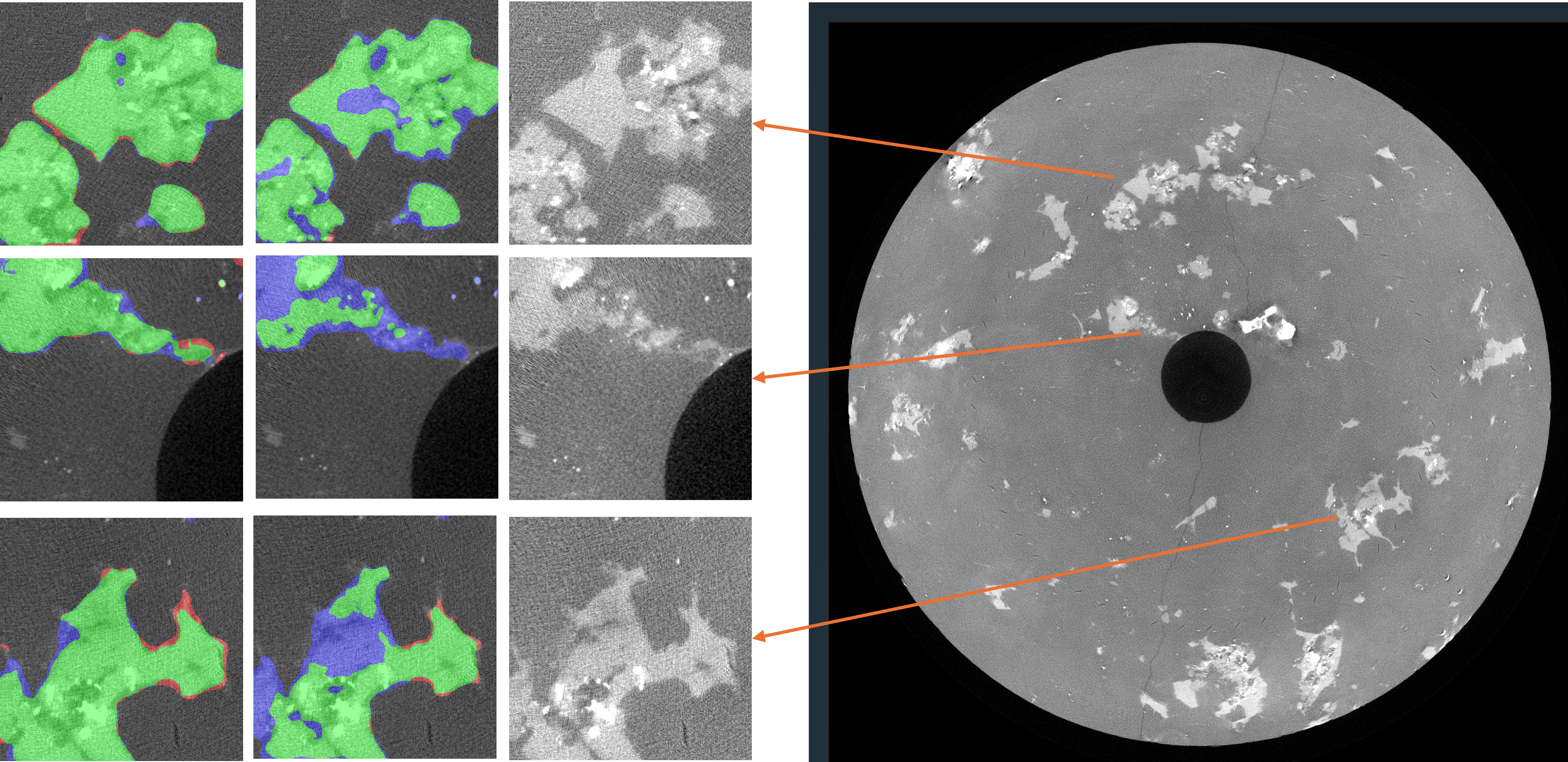
We develop deep learning models for high-resolution mineral segmentation in rock CT scans, incorporating structural cues to preserve fine mineral boundaries and geometric details. The approach enhances automated mineral identification and supports more accurate digital core analysis and geotechnical evaluation.
Fracture Recognition in Rock CT Images
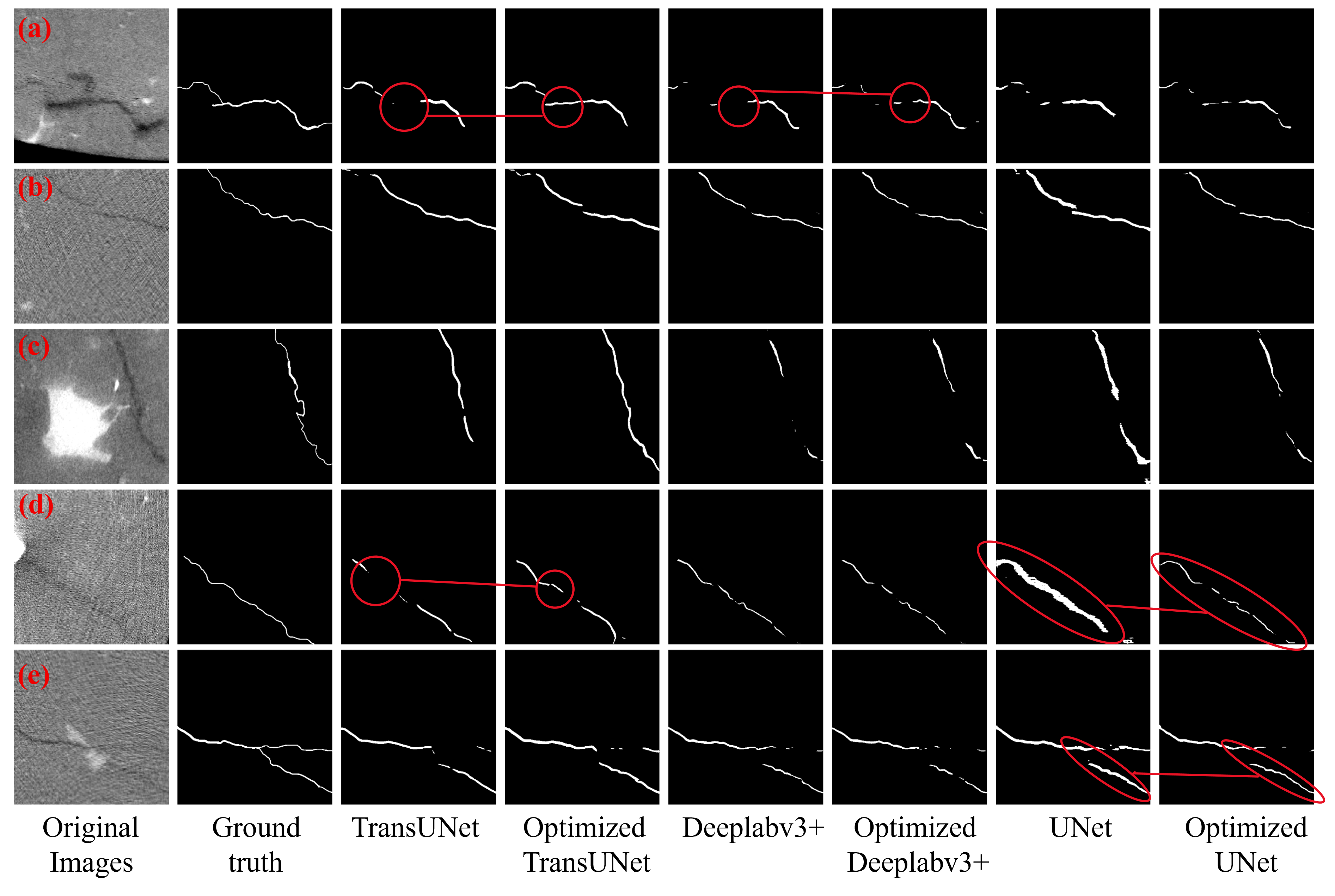
We develop morphology-aware fracture segmentation that preserves thin, continuous crack traces in rock CT images. By introducing a Frangi-inspired structural regularization, the model mitigates over-thickening and fragmentation, yielding more geometrically consistent and connected fracture predictions for robust geomechanical interpretation.
AI-Enhanced Lithology Classification Across Boreholes
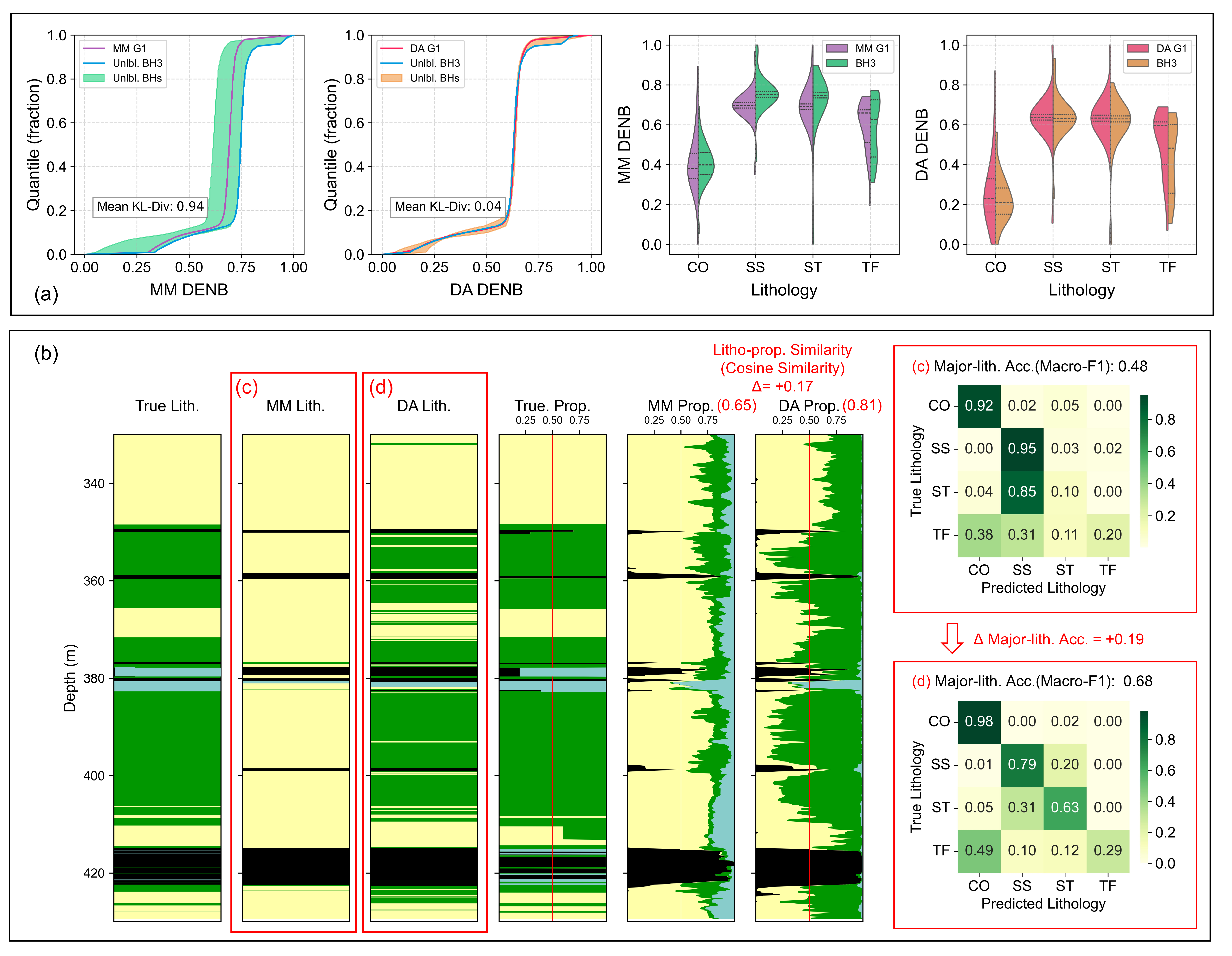
We develope a simple yet effective data adaptation method to improve lithology classification from geophysical logs across unlabelled boreholes. By aligning log quantiles between reference and target holes, the approach reduces domain variability and boosts model transferability.
Rock Mass Strength Estimation from Borehole Logs

We use machine-learning models to estimate rock strength parameters from borehole geophysical logs, enabling continuous, high-resolution strength profiling where laboratory testing is sparse. By learning the nonlinear relationships between multi-log responses and UCS, the approach improves prediction accuracy over conventional empirical correlations and supports faster geotechnical characterisation for downstream modelling and engineering analysis.
High-Definition 3D Modelling
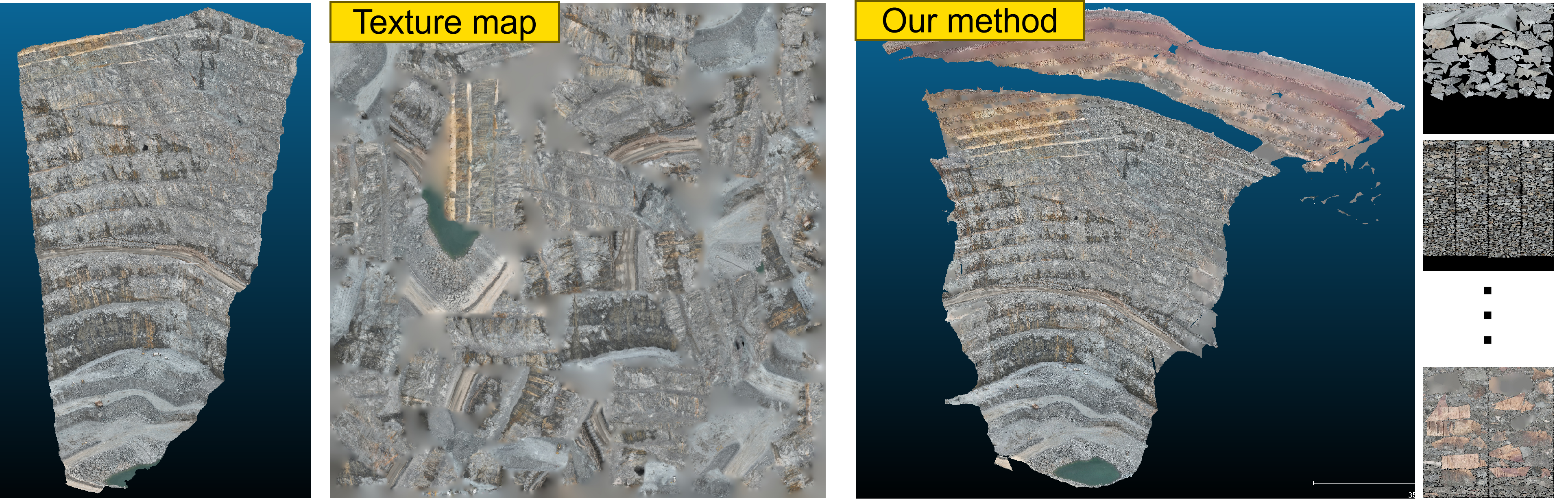
We reconstruct high-definition 3D models by fusing multi-source imagery (e.g., UAV/drone survey images and on-site photographs) with robust geometry reconstruction and texture mapping. Compared with the mine-provided 3D models, our results achieve similar geometric fidelity while delivering substantially clearer texture details, enabling more interpretable visual inspection and more reliable spatial context for geotechnical analysis.
In-situ Stress Estimation
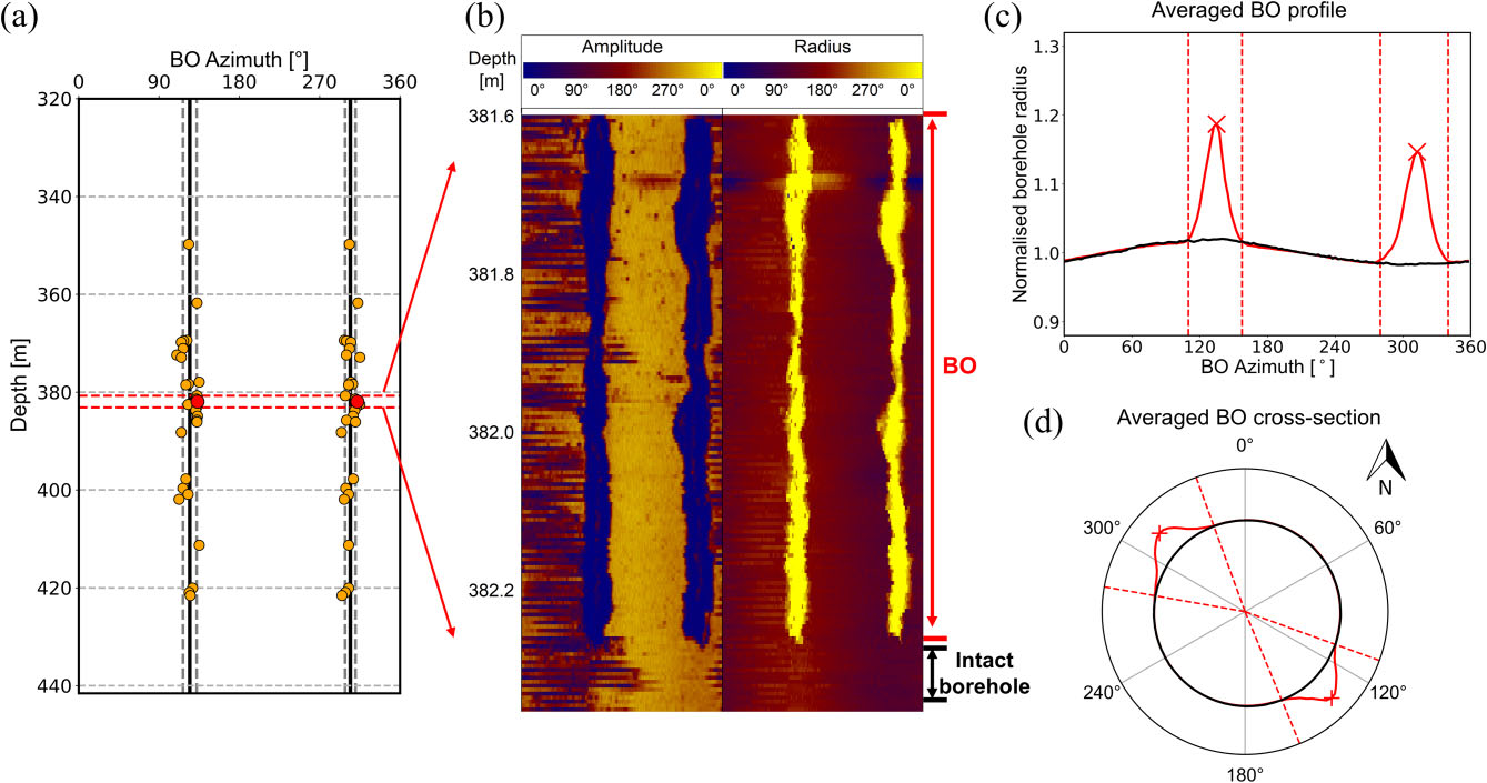
We leverage borehole breakout (BO) observations to estimate in-situ stress magnitudes where conventional measurements are limited. We develop machine-learning models to infer both maximum and minimum horizontal stresses from multiscale BO features, enabling scalable and data-driven stress profiling for subsurface and underground engineering applications.
Gas Content Estimation from Geophysical Logs
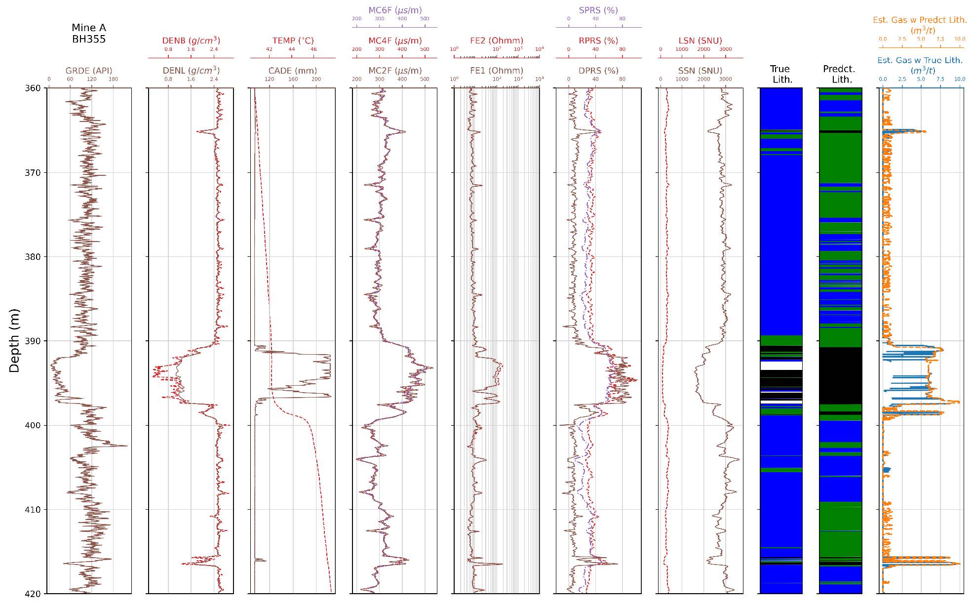
We estimate coal seam gas content from geophysical logs using supervised machine-learning models. The workflow supports both direct prediction from multi-log inputs and an indirect, physics-guided pathway, where ML first predicts key proximate parameters and a Langmuir isotherm model is then used to compute adsorbed gas content. This hybrid strategy improves robustness and transferability across boreholes, enabling fast, scalable gas content profiling for subsurface decision-making.
AI-Accelerated Numerical Simulation
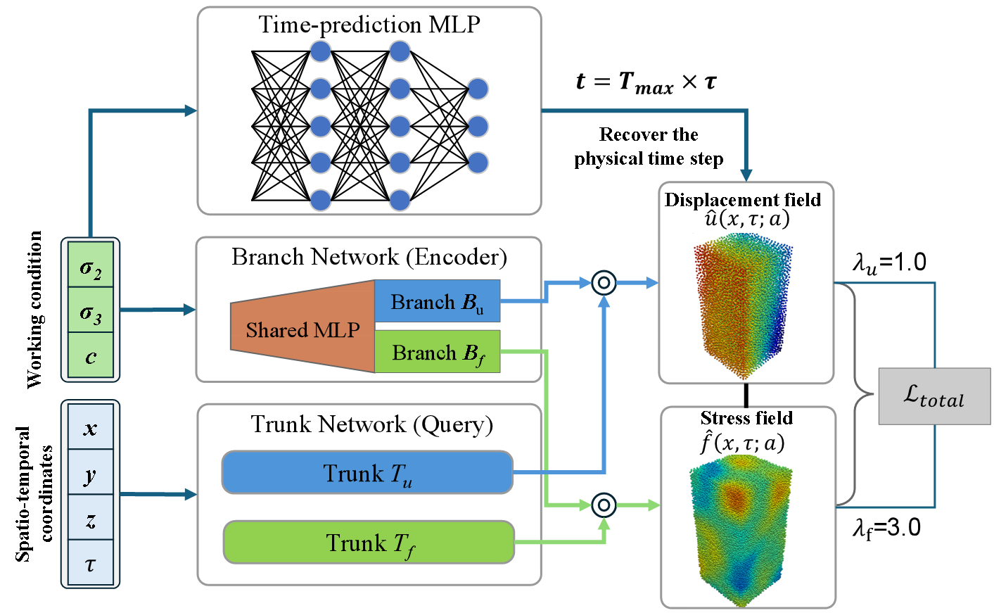
We develop a neural operator–based surrogate acceleration framework applicable to a wide range of computationally intensive numerical and multi-physics simulations. By learning the mapping from system inputs and loading conditions to full spatio-temporal field responses, the framework delivers high-fidelity predictions at dramatically reduced computational cost. As a representative application, we accelerate grain-based discrete element method (GB-DEM) simulations under true triaxial loading, accurately capturing displacement and stress evolution while achieving orders-of-magnitude speedup, enabling scalable parametric studies and rapid engineering decision support.